{
"uuid": "9dbd24da-982a-4167-b461-5164914e757c",
"type": "records",
"etag": "7edf8b81d6e57c7eb03e01789c274b5751817aee",
"data": {
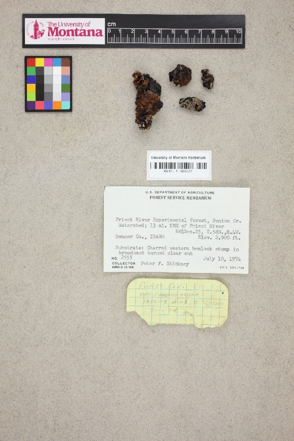
"dwc:startDayOfYear": "191",
"dwc:verbatimCoordinates": "TRS: T58N R4W sec 25 NW 1/4 B-ID",
"dwc:county": "Bonner County",
"dwc:recordedBy": "P. F. Stickney",
"dwc:georeferenceSources": "georef batch tool 2015-02-10; GeoLocate",
"dcterms:references": "https://mycoportal.org/portal/collections/individual/index.php?occid=1959528",
"dwc:occurrenceID": "4a39b952-06b1-45cf-bcf1-6883e08810a0",
"dwc:verbatimElevation": "2,900 ft.",
"id": "1959528",
"dwc:stateProvince": "Idaho",
"dwc:eventDate": "1974-07-10",
"dwc:collectionID": "9d863f79-0cb6-4493-9872-8f72d6c79e69",
"dwc:institutionCode": "MONTU",
"dwc:country": "USA",
"idigbio:recordId": "urn:uuid:4a39b952-06b1-45cf-bcf1-6883e08810a0",
"dwc:georeferenceRemarks": "Georeferenced to Benton Creek with uncertainty radius encompassing entire creek and creek area, approximately 13 miles north of Priest River mouth at Pend Oreille River.",
"symbiota:recordEnteredBy": "Michael Yost",
"dwc:decimalLatitude": "48.351484",
"dwc:occurrenceRemarks": "No scientific name provided.",
"dwc:basisOfRecord": "PreservedSpecimen",
"dc:rights": "http://creativecommons.org/publicdomain/zero/1.0/",
"dwc:habitat": "In broadcast burned clear cut.; Charred western hemlock stump.",
"dwc:locality": "Priest River Experimental Forest, Benton Creek Watershed, 13 miles north-northeast of Priest River.",
"dwc:georeferenceVerificationStatus": "reviewed - high confidence",
"dwc:geodeticDatum": "WGS84",
"dwc:minimumElevationInMeters": "884",
"dwc:catalogNumber": "MONTU-F-000803",
"dwc:month": "7",
"dwc:decimalLongitude": "-116.814653",
"dwc:georeferencedBy": "Michael Yost (2015-02-10 23:13:05)",
"dwc:recordNumber": "2555",
"dwc:georeferenceProtocol": "GBIF Best Practices",
"dcterms:modified": "2015-08-11 11:37:50",
"dwc:coordinateUncertaintyInMeters": "2665",
"dwc:day": "10",
"dwc:year": "1974"
},
"indexTerms": {
"recordset": "7340c0df-8829-4197-9dc7-0328b8e7f5dd",
"dqs": 0.2608695652173913,
"stateprovince": "idaho",
"county": "bonner county",
"catalognumber": "montu-f-000803",
"startdayofyear": 191,
"collector": "p. f. stickney",
"continent": "north america",
"uuid": "9dbd24da-982a-4167-b461-5164914e757c",
"countrycode": "usa",
"basisofrecord": "preservedspecimen",
"institutioncode": "montu",
"mediarecords": [
"cca4e05c-89f0-464b-bf29-b76fc67e4506"
],
"datecollected": "1974-07-10T00:00:00+00:00",
"etag": "7edf8b81d6e57c7eb03e01789c274b5751817aee",
"recordnumber": "2555",
"minelevation": 884,
"hasImage": true,
"collectionid": "9d863f79-0cb6-4493-9872-8f72d6c79e69",
"locality": "priest river experimental forest, benton creek watershed, 13 miles north-northeast of priest river.",
"hasMedia": true,
"coordinateuncertainty": 2665,
"datemodified": "2021-04-19T22:44:35.141833+00:00",
"occurrenceid": "4a39b952-06b1-45cf-bcf1-6883e08810a0",
"country": "united states",
"geopoint": {
"lat": 48.351484,
"lon": -116.814653
},
"flags": [
"dwc_country_replaced",
"idigbio_isocountrycode_added",
"dwc_continent_added"
],
"recordids": [
"urn:uuid:4a39b952-06b1-45cf-bcf1-6883e08810a0",
"7340c0df-8829-4197-9dc7-0328b8e7f5dd\\4a39b952-06b1-45cf-bcf1-6883e08810a0",
"7340c0df-8829-4197-9dc7-0328b8e7f5dd\\1959528"
],
"eventdate": "1974-07-10",
"indexData": {
"dwc:startDayOfYear": "191",
"dwc:verbatimCoordinates": "TRS: T58N R4W sec 25 NW 1/4 B-ID",
"dwc:county": "Bonner County",
"dwc:recordedBy": "P. F. Stickney",
"idigbio:uuid": "9dbd24da-982a-4167-b461-5164914e757c",
"dwc:locality": "Priest River Experimental Forest, Benton Creek Watershed, 13 miles north-northeast of Priest River.",
"dwc:habitat": "In broadcast burned clear cut.; Charred western hemlock stump.",
"dwc:georeferenceProtocol": "GBIF Best Practices",
"idigbio:recordIds": [
"urn:uuid:4a39b952-06b1-45cf-bcf1-6883e08810a0",
"7340c0df-8829-4197-9dc7-0328b8e7f5dd\\4a39b952-06b1-45cf-bcf1-6883e08810a0",
"7340c0df-8829-4197-9dc7-0328b8e7f5dd\\1959528"
],
"dwc:occurrenceID": "4a39b952-06b1-45cf-bcf1-6883e08810a0",
"dwc:verbatimElevation": "2,900 ft.",
"symbiota:recordEnteredBy": "Michael Yost",
"idigbio:parent": "7340c0df-8829-4197-9dc7-0328b8e7f5dd",
"dwc:stateProvince": "Idaho",
"dwc:eventDate": "1974-07-10",
"dwc:collectionID": "9d863f79-0cb6-4493-9872-8f72d6c79e69",
"dwc:country": "united states",
"idigbio:recordId": "urn:uuid:4a39b952-06b1-45cf-bcf1-6883e08810a0",
"idigbio:etag": "7edf8b81d6e57c7eb03e01789c274b5751817aee",
"dwc:georeferenceRemarks": "Georeferenced to Benton Creek with uncertainty radius encompassing entire creek and creek area, approximately 13 miles north of Priest River mouth at Pend Oreille River.",
"id": "1959528",
"dwc:decimalLatitude": "48.351484",
"dwc:occurrenceRemarks": "No scientific name provided.",
"dwc:basisOfRecord": "PreservedSpecimen",
"dwc:continent": "north america",
"dc:rights": "http://creativecommons.org/publicdomain/zero/1.0/",
"flag_dwc_country_replaced": true,
"dwc:geodeticDatum": "WGS84",
"idigbio:siblings": {
"mediarecord": [
"cca4e05c-89f0-464b-bf29-b76fc67e4506"
]
},
"flag_idigbio_isocountrycode_added": true,
"dcterms:references": "https://mycoportal.org/portal/collections/individual/index.php?occid=1959528",
"idigbio:dateModified": "2021-04-19T22:44:35.141833",
"dwc:georeferenceSources": "georef batch tool 2015-02-10; GeoLocate",
"dwc:institutionCode": "MONTU",
"dwc:georeferenceVerificationStatus": "reviewed - high confidence",
"dwc:catalogNumber": "MONTU-F-000803",
"dwc:month": "7",
"dwc:decimalLongitude": "-116.814653",
"dwc:georeferencedBy": "Michael Yost (2015-02-10 23:13:05)",
"flag_dwc_continent_added": true,
"dwc:recordNumber": "2555",
"idigbio:isocountrycode": "usa",
"dwc:minimumElevationInMeters": "884",
"dcterms:modified": "2015-08-11 11:37:50",
"dwc:coordinateUncertaintyInMeters": "2665",
"dwc:day": "10",
"dwc:year": "1974"
}
},
"attribution": {
"uuid": "7340c0df-8829-4197-9dc7-0328b8e7f5dd",
"name": "University of Montana Herbarium",
"description": "The Herbarium at The University of Montana (MONTU, http://herbarium.dbs.umt.edu) contains over 150,000 plant specimens and has the largest and best representation of the flora of the Northern Rocky Mountains in the world. The Herbarium is particularly well-known for its collections from the alpine and montane regions of Montana. Our vascular plant collections can be accessed via http://pnwherbaria.org. MONTU is also home to the Montana Diatom collection (http://herbarium.dbs.umt.edu/diatoms.asp), and we are excited to have our fungi collection included in the Mycoportal Database.",
"logo": "https://www.mycoportal.org/portal/self/images/collicons/montu.jpg",
"url": "http://herbarium.dbs.umt.edu/",
"emllink": "https://www.mycoportal.org/portal/collections/datasets/emlhandler.php?collid=28",
"archivelink": "https://www.mycoportal.org/portal/content/dwca/montu_dwc-a.zip",
"contacts": [
{
"email": "help@mycoportal.org"
},
{
"email": "help@mycoportal.org"
},
{
"email": "Marilyn.marler@umontana.edu"
},
{
"last_name": "Marilyn Marler",
"email": "Marilyn.marler@umontana.edu"
},
{
"last_name": "Marilyn Marler",
"email": "Marilyn.marler@umontana.edu"
}
],
"data_rights": "CC0",
"publisher": "e9c875f0-d9c9-426b-bdc8-0999eb1b6deb",
"totalCount": 1415
}
}
 The Herbarium at The University of Montana (MONTU, http://herbarium.dbs.umt.edu) contains over 150,000 plant specimens and has the largest and best representation of the flora of the Northern Rocky Mountains in the world. The Herbarium is particularly well-known for its collections from the alpine and montane regions of Montana. Our vascular plant collections can be accessed via http://pnwherbaria.org. MONTU is also home to the Montana Diatom collection (http://herbarium.dbs.umt.edu/diatoms.asp), and we are excited to have our fungi collection included in the Mycoportal Database.