{
"uuid": "a06fdaca-b534-4b26-b96a-e4e0becf275f",
"type": "records",
"etag": "92b8715365c314040be0c2b508f511367ad66362",
"data": {
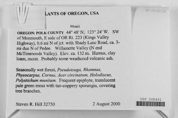
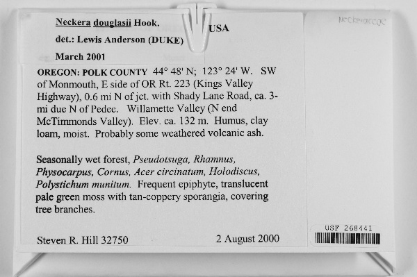
"dwc:verbatimCoordinates": "44 48' N 123 24' W",
"dwc:county": "Polk",
"dwc:recordedBy": "Steven R. Hill",
"dwc:georeferenceSources": "georef batch tool 2015-01-08; GeoLocate",
"dcterms:references": "http://bryophyteportal.org/portal/collections/individual/index.php?occid=2405099",
"dwc:occurrenceID": "2405099",
"dwc:dateIdentified": "2001-03-00",
"symbiota:recordEnteredBy": "kmannis",
"dwc:stateProvince": "Oregon",
"dwc:eventDate": "2000-08-02",
"dwc:collectionID": "45e409c3-e701-449d-8dde-45d9e0394d1c",
"dwc:country": "United States",
"idigbio:recordId": "urn:uuid:869b98a8-9eab-48eb-b144-b4bade505c75",
"dwc:georeferenceRemarks": "Valley Ecosystem. (North end McTimmonds Valley). Elevation about 132 meters. Coordinate",
"dwc:decimalLatitude": "44.797056",
"dwc:occurrenceRemarks": "frequent epiphyte, translucent pale green moss with tan-coppery sporangia, covering tree branches",
"dwc:basisOfRecord": "PreservedSpecimen",
"dc:rights": "http://creativecommons.org/licenses/by-nc/3.0/",
"dwc:identifiedBy": "Lewis Anderson",
"dwc:coordinateUncertaintyInMeters": "200",
"dwc:habitat": "seasonally wet forest; humus, clay loam, moist. Probably some weathered volcanic ash",
"dwc:locality": "SW of Monmouth, E side of OR Rt. 223 (Kings Valley Highway), 0.6 mi N of jet. with Shady Lane Road, 3-mi due N of Pedee. Willamette Valley,N end McTimmonds Valley",
"dwc:institutionCode": "USF",
"dwc:georeferenceVerificationStatus": "reviewed - high confidence",
"dwc:catalogNumber": "USF 268441",
"dwc:decimalLongitude": "-123.41278",
"dwc:scientificName": "Neckera douglassii",
"dwc:georeferencedBy": "ssmigielski92 (2015-01-08 11:44:21)",
"dwc:verbatimEventDate": "2 August 2000",
"dwc:recordNumber": "32750",
"dwc:minimumElevationInMeters": "132",
"dcterms:modified": "2015-08-11 13:01:54",
"dwc:associatedTaxa": "Pseudotsuga, Rhamnus, Physocarpus, Cornus, Acer circinatum, Holodiscus, Polystichum munitum"
},
"indexTerms": {
"recordset": "0072bf11-a354-4998-8730-c0cb4cfc9517",
"dqs": 0.2898550724637681,
"stateprovince": "oregon",
"county": "polk",
"catalognumber": "usf 268441",
"startdayofyear": 215,
"collector": "steven r. hill",
"continent": "north america",
"uuid": "a06fdaca-b534-4b26-b96a-e4e0becf275f",
"countrycode": "usa",
"basisofrecord": "preservedspecimen",
"institutioncode": "usf",
"mediarecords": [
"5b617635-17d8-4f97-95d1-66abac345e0c",
"c84a9361-74e1-413d-ab2c-2dd75c38a399"
],
"datecollected": "2000-08-02T00:00:00+00:00",
"etag": "92b8715365c314040be0c2b508f511367ad66362",
"recordnumber": "32750",
"minelevation": 132,
"hasImage": true,
"collectionid": "45e409c3-e701-449d-8dde-45d9e0394d1c",
"scientificname": "neckera douglassii",
"locality": "sw of monmouth, e side of or rt. 223 (kings valley highway), 0.6 mi n of jet. with shady lane road, 3-mi due n of pedee. willamette valley,n end mctimmonds valley",
"hasMedia": true,
"coordinateuncertainty": 200,
"datemodified": "2015-09-30T14:07:33.266062+00:00",
"occurrenceid": "2405099",
"country": "united states",
"geopoint": {
"lat": 44.797056,
"lon": -123.41278
},
"flags": [
"geopoint_datum_missing",
"idigbio_isocountrycode_added",
"dwc_continent_added"
],
"verbatimeventdate": "2 august 2000",
"recordids": [
"urn:uuid:869b98a8-9eab-48eb-b144-b4bade505c75",
"0072bf11-a354-4998-8730-c0cb4cfc9517\\2405099"
],
"eventdate": "2000-08-02",
"indexData": {
"dwc:verbatimCoordinates": "44 48' N 123 24' W",
"dwc:county": "Polk",
"dwc:recordedBy": "Steven R. Hill",
"idigbio:uuid": "a06fdaca-b534-4b26-b96a-e4e0becf275f",
"dwc:locality": "SW of Monmouth, E side of OR Rt. 223 (Kings Valley Highway), 0.6 mi N of jet. with Shady Lane Road, 3-mi due N of Pedee. Willamette Valley,N end McTimmonds Valley",
"dwc:habitat": "seasonally wet forest; humus, clay loam, moist. Probably some weathered volcanic ash",
"idigbio:recordIds": [
"urn:uuid:869b98a8-9eab-48eb-b144-b4bade505c75",
"0072bf11-a354-4998-8730-c0cb4cfc9517\\2405099"
],
"dwc:occurrenceID": "2405099",
"dwc:dateIdentified": "2001-03-00",
"symbiota:recordEnteredBy": "kmannis",
"idigbio:parent": "0072bf11-a354-4998-8730-c0cb4cfc9517",
"dwc:stateProvince": "Oregon",
"dwc:eventDate": "2000-08-02",
"dwc:collectionID": "45e409c3-e701-449d-8dde-45d9e0394d1c",
"dwc:country": "United States",
"idigbio:recordId": "urn:uuid:869b98a8-9eab-48eb-b144-b4bade505c75",
"idigbio:etag": "92b8715365c314040be0c2b508f511367ad66362",
"dwc:georeferenceRemarks": "Valley Ecosystem. (North end McTimmonds Valley). Elevation about 132 meters. Coordinate",
"dwc:decimalLatitude": "44.797056",
"dwc:occurrenceRemarks": "frequent epiphyte, translucent pale green moss with tan-coppery sporangia, covering tree branches",
"dwc:basisOfRecord": "PreservedSpecimen",
"dwc:continent": "north america",
"dc:rights": "http://creativecommons.org/licenses/by-nc/3.0/",
"dwc:identifiedBy": "Lewis Anderson",
"dwc:associatedTaxa": "Pseudotsuga, Rhamnus, Physocarpus, Cornus, Acer circinatum, Holodiscus, Polystichum munitum",
"idigbio:siblings": {
"mediarecord": [
"5b617635-17d8-4f97-95d1-66abac345e0c",
"c84a9361-74e1-413d-ab2c-2dd75c38a399"
]
},
"flag_idigbio_isocountrycode_added": true,
"dcterms:references": "http://bryophyteportal.org/portal/collections/individual/index.php?occid=2405099",
"idigbio:dateModified": "2015-09-30T14:07:33.266062",
"dwc:georeferenceSources": "georef batch tool 2015-01-08; GeoLocate",
"dwc:institutionCode": "USF",
"dwc:georeferenceVerificationStatus": "reviewed - high confidence",
"dwc:catalogNumber": "USF 268441",
"dwc:decimalLongitude": "-123.41278",
"dwc:scientificName": "Neckera douglassii",
"dwc:georeferencedBy": "ssmigielski92 (2015-01-08 11:44:21)",
"dwc:verbatimEventDate": "2 August 2000",
"flag_dwc_continent_added": true,
"dwc:recordNumber": "32750",
"idigbio:isocountrycode": "usa",
"dwc:minimumElevationInMeters": "132",
"dcterms:modified": "2015-08-11 13:01:54",
"dwc:coordinateUncertaintyInMeters": "200"
}
},
"attribution": {
"uuid": "0072bf11-a354-4998-8730-c0cb4cfc9517",
"name": "University of South Florida Herbarium",
"description": "The USF Herbarium, with over 270,000 specimens, is the second largest collection in Florida, the seventh largest in the southeastern United States, and ranks in the upper third of the world's herbaria in size.",
"logo": "http://bryophyteportal.org/portal/images/collicons/USF.jpg",
"url": "http://florida.plantatlas.usf.edu",
"emllink": "http://bryophyteportal.org/portal/collections/datasets/dwc/usf_dwc-a.eml",
"archivelink": "http://bryophyteportal.org/portal/collections/datasets/dwc/usf_dwc-a.zip",
"contacts": [
{
"email": "egbot@asu.edu"
},
{
"first_name": "Alan R. Franck, Ph.D., Curator",
"email": "afranck@mail.usf.edu"
}
],
"data_rights": "CC3 BY-NC",
"publisher": "4e1beef9-d7c0-4ac0-87df-065bc5a55361",
"totalCount": 2856
}
}
 The USF Herbarium, with over 270,000 specimens, is the second largest collection in Florida, the seventh largest in the southeastern United States, and ranks in the upper third of the world's herbaria in size.