{
"uuid": "af9d6b76-8609-47b5-8384-e1b08e71a791",
"type": "records",
"etag": "ee012316d2e69b4367216d1159c05f49a403ed0d",
"data": {
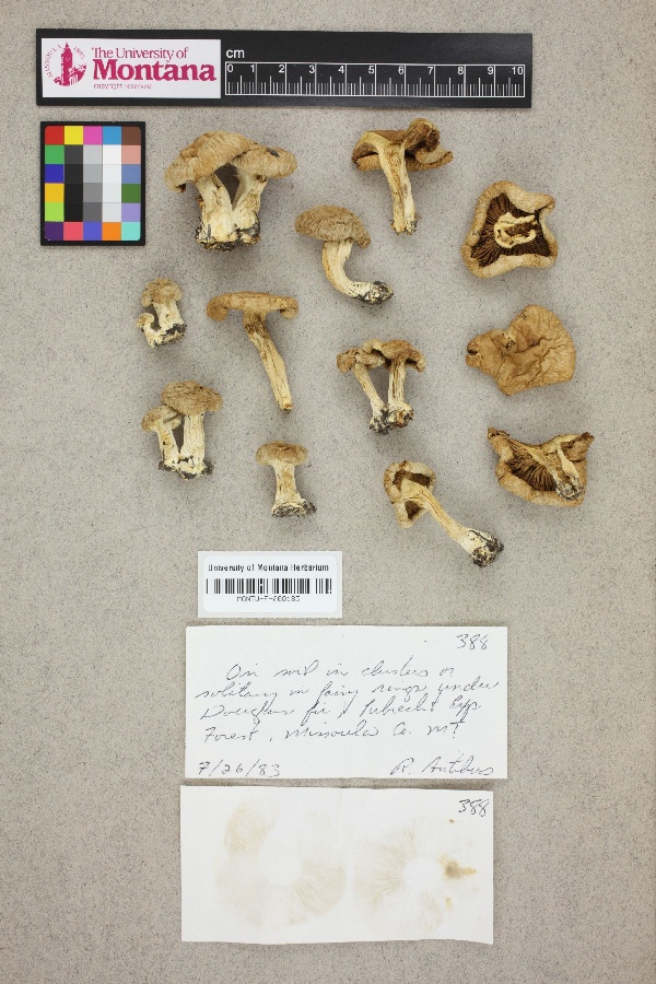
"dwc:startDayOfYear": "207",
"dwc:county": "Missoula County",
"dwc:recordedBy": "R. Antibus",
"dwc:georeferenceSources": "georef batch tool 2015-01-14; GeoLocate",
"dcterms:references": "https://mycoportal.org/portal/collections/individual/index.php?occid=1952982",
"dwc:occurrenceID": "fb63052b-70d3-4cd7-b390-9693efd583bd",
"id": "1952982",
"dwc:stateProvince": "Montana",
"dwc:eventDate": "1983-07-26",
"dwc:collectionID": "9d863f79-0cb6-4493-9872-8f72d6c79e69",
"dwc:institutionCode": "MONTU",
"dwc:country": "USA",
"idigbio:recordId": "urn:uuid:fb63052b-70d3-4cd7-b390-9693efd583bd",
"dwc:georeferenceRemarks": "Georeferenced to approximate center of Lubrecht Experimental Forest with uncertainty radius extending out to eastern border of Missoula County, the outermost boundary of Lubrecht Experimental Forest.",
"symbiota:recordEnteredBy": "Michael Yost",
"dwc:decimalLatitude": "46.892515",
"dwc:occurrenceRemarks": "No scientific name provided.; In clusters or solitary in fairy rings.",
"dwc:basisOfRecord": "PreservedSpecimen",
"dc:rights": "http://creativecommons.org/publicdomain/zero/1.0/",
"dwc:habitat": "Under Douglas fir.; On soil.",
"dwc:locality": "Lubrecht Experimental Forest.",
"dwc:geodeticDatum": "WGS84",
"dwc:georeferenceVerificationStatus": "reviewed - high confidence",
"dwc:catalogNumber": "MONTU-F-000183",
"dwc:month": "7",
"dwc:decimalLongitude": "-113.434226",
"dwc:georeferencedBy": "Michael Yost (2015-01-14 17:21:24)",
"dwc:recordNumber": "388",
"dwc:georeferenceProtocol": "GBIF Best Practices",
"dcterms:modified": "2015-08-11 11:37:50",
"dwc:coordinateUncertaintyInMeters": "9966",
"dwc:day": "26",
"dwc:year": "1983"
},
"indexTerms": {
"recordset": "7340c0df-8829-4197-9dc7-0328b8e7f5dd",
"dqs": 0.2463768115942029,
"stateprovince": "montana",
"county": "missoula county",
"catalognumber": "montu-f-000183",
"startdayofyear": 207,
"collector": "r. antibus",
"continent": "north america",
"uuid": "af9d6b76-8609-47b5-8384-e1b08e71a791",
"countrycode": "usa",
"basisofrecord": "preservedspecimen",
"institutioncode": "montu",
"mediarecords": [
"5f4b858b-ae5f-4076-843e-d585f22aa518"
],
"datecollected": "1983-07-26T00:00:00+00:00",
"etag": "ee012316d2e69b4367216d1159c05f49a403ed0d",
"recordnumber": "388",
"hasImage": true,
"collectionid": "9d863f79-0cb6-4493-9872-8f72d6c79e69",
"locality": "lubrecht experimental forest.",
"hasMedia": true,
"coordinateuncertainty": 9966,
"datemodified": "2021-04-19T22:44:35.141833+00:00",
"occurrenceid": "fb63052b-70d3-4cd7-b390-9693efd583bd",
"country": "united states",
"geopoint": {
"lat": 46.892515,
"lon": -113.434226
},
"flags": [
"dwc_country_replaced",
"idigbio_isocountrycode_added",
"dwc_continent_added"
],
"recordids": [
"urn:uuid:fb63052b-70d3-4cd7-b390-9693efd583bd",
"7340c0df-8829-4197-9dc7-0328b8e7f5dd\\1952982",
"7340c0df-8829-4197-9dc7-0328b8e7f5dd\\fb63052b-70d3-4cd7-b390-9693efd583bd"
],
"eventdate": "1983-07-26",
"indexData": {
"dwc:startDayOfYear": "207",
"dwc:county": "Missoula County",
"dwc:recordedBy": "R. Antibus",
"idigbio:uuid": "af9d6b76-8609-47b5-8384-e1b08e71a791",
"dwc:georeferenceSources": "georef batch tool 2015-01-14; GeoLocate",
"dwc:habitat": "Under Douglas fir.; On soil.",
"idigbio:recordIds": [
"urn:uuid:fb63052b-70d3-4cd7-b390-9693efd583bd",
"7340c0df-8829-4197-9dc7-0328b8e7f5dd\\1952982",
"7340c0df-8829-4197-9dc7-0328b8e7f5dd\\fb63052b-70d3-4cd7-b390-9693efd583bd"
],
"dwc:occurrenceID": "fb63052b-70d3-4cd7-b390-9693efd583bd",
"symbiota:recordEnteredBy": "Michael Yost",
"idigbio:parent": "7340c0df-8829-4197-9dc7-0328b8e7f5dd",
"dwc:stateProvince": "Montana",
"dwc:eventDate": "1983-07-26",
"dwc:collectionID": "9d863f79-0cb6-4493-9872-8f72d6c79e69",
"dwc:institutionCode": "MONTU",
"dwc:country": "united states",
"idigbio:recordId": "urn:uuid:fb63052b-70d3-4cd7-b390-9693efd583bd",
"idigbio:etag": "ee012316d2e69b4367216d1159c05f49a403ed0d",
"dwc:georeferenceRemarks": "Georeferenced to approximate center of Lubrecht Experimental Forest with uncertainty radius extending out to eastern border of Missoula County, the outermost boundary of Lubrecht Experimental Forest.",
"id": "1952982",
"dwc:decimalLatitude": "46.892515",
"dwc:occurrenceRemarks": "No scientific name provided.; In clusters or solitary in fairy rings.",
"dwc:basisOfRecord": "PreservedSpecimen",
"dwc:continent": "north america",
"dc:rights": "http://creativecommons.org/publicdomain/zero/1.0/",
"flag_dwc_country_replaced": true,
"idigbio:siblings": {
"mediarecord": [
"5f4b858b-ae5f-4076-843e-d585f22aa518"
]
},
"flag_idigbio_isocountrycode_added": true,
"dcterms:references": "https://mycoportal.org/portal/collections/individual/index.php?occid=1952982",
"idigbio:dateModified": "2021-04-19T22:44:35.141833",
"dwc:locality": "Lubrecht Experimental Forest.",
"dwc:geodeticDatum": "WGS84",
"dwc:georeferenceVerificationStatus": "reviewed - high confidence",
"dwc:catalogNumber": "MONTU-F-000183",
"dwc:month": "7",
"dwc:decimalLongitude": "-113.434226",
"dwc:georeferencedBy": "Michael Yost (2015-01-14 17:21:24)",
"flag_dwc_continent_added": true,
"dwc:recordNumber": "388",
"idigbio:isocountrycode": "usa",
"dwc:georeferenceProtocol": "GBIF Best Practices",
"dcterms:modified": "2015-08-11 11:37:50",
"dwc:coordinateUncertaintyInMeters": "9966",
"dwc:day": "26",
"dwc:year": "1983"
}
},
"attribution": {
"uuid": "7340c0df-8829-4197-9dc7-0328b8e7f5dd",
"name": "University of Montana Herbarium",
"description": "The Herbarium at The University of Montana (MONTU, http://herbarium.dbs.umt.edu) contains over 150,000 plant specimens and has the largest and best representation of the flora of the Northern Rocky Mountains in the world. The Herbarium is particularly well-known for its collections from the alpine and montane regions of Montana. Our vascular plant collections can be accessed via http://pnwherbaria.org. MONTU is also home to the Montana Diatom collection (http://herbarium.dbs.umt.edu/diatoms.asp), and we are excited to have our fungi collection included in the Mycoportal Database.",
"logo": "https://www.mycoportal.org/portal/self/images/collicons/montu.jpg",
"url": "http://herbarium.dbs.umt.edu/",
"emllink": "https://www.mycoportal.org/portal/collections/datasets/emlhandler.php?collid=28",
"archivelink": "https://www.mycoportal.org/portal/content/dwca/montu_dwc-a.zip",
"contacts": [
{
"email": "help@mycoportal.org"
},
{
"email": "help@mycoportal.org"
},
{
"email": "Marilyn.marler@umontana.edu"
},
{
"last_name": "Marilyn Marler",
"email": "Marilyn.marler@umontana.edu"
},
{
"last_name": "Marilyn Marler",
"email": "Marilyn.marler@umontana.edu"
}
],
"data_rights": "CC0",
"publisher": "e9c875f0-d9c9-426b-bdc8-0999eb1b6deb",
"totalCount": 1415
}
}
 The Herbarium at The University of Montana (MONTU, http://herbarium.dbs.umt.edu) contains over 150,000 plant specimens and has the largest and best representation of the flora of the Northern Rocky Mountains in the world. The Herbarium is particularly well-known for its collections from the alpine and montane regions of Montana. Our vascular plant collections can be accessed via http://pnwherbaria.org. MONTU is also home to the Montana Diatom collection (http://herbarium.dbs.umt.edu/diatoms.asp), and we are excited to have our fungi collection included in the Mycoportal Database.