{
"uuid": "d78a492e-e026-41c8-9d10-f54ffaaf73a2",
"type": "records",
"etag": "242683a6ab8d950a612610406cf06f12b6c4e8d0",
"data": {
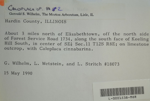
"dwc:verbatimCoordinates": "TRS: T12S R8E SE 1/4 Sec. 11",
"dwc:county": "Hardin",
"dwc:recordedBy": "Gerould Wilhelm; L. Wetstein, L. Stritch",
"dwc:georeferenceSources": "2016-01-14; Robert Anglin script for Township Range Section in GeoLocate",
"dcterms:references": "https://lichenportal.org/portal/collections/individual/index.php?occid=1416879",
"dwc:scientificNameAuthorship": "Th. Fr.",
"dwc:occurrenceID": "cb8689a9-aac7-4231-a6b5-b1fdfaeb509e",
"id": "1416879",
"dwc:stateProvince": "Illinois",
"dwc:eventDate": "1990-05-15",
"dwc:collectionID": "36ea544b-df08-4f21-80e5-dd1c0bdc39c6",
"dwc:country": "U.S.A.",
"dwc:georeferenceRemarks": "lat/long = TRS; uncertainty = extent of Section",
"symbiota:recordEnteredBy": "kelueders",
"dwc:decimalLatitude": "37.48882",
"dwc:basisOfRecord": "PreservedSpecimen",
"dc:rights": "http://creativecommons.org/licenses/by-nc/4.0/",
"dwc:identifiedBy": "Gerould S. Wilhelm",
"dwc:coordinateUncertaintyInMeters": "1100",
"symbiota:recordID": "cb8689a9-aac7-4231-a6b5-b1fdfaeb509e",
"dwc:habitat": "on limestone outcrop",
"dwc:locality": "About 3 miles north of Elizabethtown, off the north side of Forest Service Road 1734, along the south face of Keeling Hill South.",
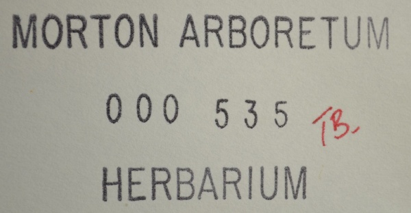
"dwc:institutionCode": "MOR",
"dwc:catalogNumber": "L-0001538-MOR",
"dwc:Identification": [
{
"dwc:identifiedBy": "Gerould S. Wilhelm",
"idigbio:recordID": "urn:uuid:63e244e3-84dd-481b-9cc7-9181d2cc4f01",
"coreid": "1416879",
"dwc:scientificNameAuthorship": "Th. Fr.",
"dwc:dateIdentified": "s.d.",
"dcterms:modified": "2023-04-25 01:28:23",
"dwc:scientificName": "Caloplaca sp.",
"dwc:identificationQualifier": "#2"
}
],
"dwc:decimalLongitude": "-88.292604",
"dwc:scientificName": "Caloplaca sp.",
"dwc:otherCatalogNumbers": "000535",
"dwc:georeferencedBy": "ranglin",
"dwc:verbatimEventDate": "15 May 1990",
"dwc:recordNumber": "18073",
"dwc:identificationQualifier": "#2",
"dcterms:modified": "2023-04-25 01:43:19",
"dwc:associatedTaxa": "Caloplaca cinnabarina"
},
"indexTerms": {
"recordset": "99b04c9f-908e-42bd-92bc-41aa94b72949",
"dqs": 0.2608695652173913,
"stateprovince": "illinois",
"county": "hardin",
"catalognumber": "l-0001538-mor",
"startdayofyear": 135,
"collector": "gerould wilhelm; l. wetstein, l. stritch",
"continent": "north america",
"uuid": "d78a492e-e026-41c8-9d10-f54ffaaf73a2",
"countrycode": "usa",
"basisofrecord": "preservedspecimen",
"institutioncode": "mor",
"mediarecords": [
"2c43362b-bc9b-4d38-9b3d-b480e9c98490",
"44a56035-eda9-4a4f-95b6-8879e17ea096"
],
"datecollected": "1990-05-15T00:00:00+00:00",
"etag": "242683a6ab8d950a612610406cf06f12b6c4e8d0",
"recordnumber": "18073",
"hasImage": true,
"collectionid": "36ea544b-df08-4f21-80e5-dd1c0bdc39c6",
"scientificname": "caloplaca sp.",
"locality": "about 3 miles north of elizabethtown, off the north side of forest service road 1734, along the south face of keeling hill south.",
"hasMedia": true,
"coordinateuncertainty": 1100,
"datemodified": "2023-05-05T11:35:33.825304+00:00",
"occurrenceid": "cb8689a9-aac7-4231-a6b5-b1fdfaeb509e",
"country": "united states",
"geopoint": {
"lat": 37.48882,
"lon": -88.292604
},
"flags": [
"geopoint_datum_missing",
"dwc_country_replaced",
"idigbio_isocountrycode_added",
"dwc_continent_added"
],
"verbatimeventdate": "15 may 1990",
"recordids": [
"urn:uuid:cb8689a9-aac7-4231-a6b5-b1fdfaeb509e",
"99b04c9f-908e-42bd-92bc-41aa94b72949\\1416879",
"99b04c9f-908e-42bd-92bc-41aa94b72949\\cb8689a9-aac7-4231-a6b5-b1fdfaeb509e"
],
"eventdate": "1990-05-15",
"indexData": {
"flag_dwc_country_replaced": true,
"dwc:verbatimCoordinates": "TRS: T12S R8E SE 1/4 Sec. 11",
"dwc:county": "Hardin",
"dwc:recordedBy": "Gerould Wilhelm; L. Wetstein, L. Stritch",
"idigbio:uuid": "d78a492e-e026-41c8-9d10-f54ffaaf73a2",
"dwc:locality": "About 3 miles north of Elizabethtown, off the north side of Forest Service Road 1734, along the south face of Keeling Hill South.",
"dcterms:references": "https://lichenportal.org/portal/collections/individual/index.php?occid=1416879",
"dwc:scientificNameAuthorship": "Th. Fr.",
"idigbio:recordIds": [
"urn:uuid:cb8689a9-aac7-4231-a6b5-b1fdfaeb509e",
"99b04c9f-908e-42bd-92bc-41aa94b72949\\1416879",
"99b04c9f-908e-42bd-92bc-41aa94b72949\\cb8689a9-aac7-4231-a6b5-b1fdfaeb509e"
],
"dwc:occurrenceID": "cb8689a9-aac7-4231-a6b5-b1fdfaeb509e",
"symbiota:recordEnteredBy": "kelueders",
"idigbio:parent": "99b04c9f-908e-42bd-92bc-41aa94b72949",
"dwc:stateProvince": "Illinois",
"dwc:eventDate": "1990-05-15",
"dwc:collectionID": "36ea544b-df08-4f21-80e5-dd1c0bdc39c6",
"dwc:country": "united states",
"idigbio:etag": "242683a6ab8d950a612610406cf06f12b6c4e8d0",
"dwc:georeferenceRemarks": "lat/long = TRS; uncertainty = extent of Section",
"id": "1416879",
"dwc:decimalLatitude": "37.48882",
"dwc:basisOfRecord": "PreservedSpecimen",
"dwc:continent": "north america",
"dc:rights": "http://creativecommons.org/licenses/by-nc/4.0/",
"dwc:identifiedBy": "Gerould S. Wilhelm",
"dwc:associatedTaxa": "Caloplaca cinnabarina",
"idigbio:isocountrycode": "usa",
"idigbio:siblings": {
"mediarecord": [
"2c43362b-bc9b-4d38-9b3d-b480e9c98490",
"44a56035-eda9-4a4f-95b6-8879e17ea096"
]
},
"symbiota:recordID": "cb8689a9-aac7-4231-a6b5-b1fdfaeb509e",
"flag_idigbio_isocountrycode_added": true,
"dwc:habitat": "on limestone outcrop",
"idigbio:dateModified": "2023-05-05T11:35:33.825304",
"dwc:georeferenceSources": "2016-01-14; Robert Anglin script for Township Range Section in GeoLocate",
"dwc:institutionCode": "MOR",
"dwc:catalogNumber": "L-0001538-MOR",
"dwc:Identification": [
{
"dwc:identifiedBy": "Gerould S. Wilhelm",
"idigbio:recordID": "urn:uuid:63e244e3-84dd-481b-9cc7-9181d2cc4f01",
"coreid": "1416879",
"dwc:scientificNameAuthorship": "Th. Fr.",
"dwc:dateIdentified": "s.d.",
"dcterms:modified": "2023-04-25 01:28:23",
"dwc:scientificName": "Caloplaca sp.",
"dwc:identificationQualifier": "#2"
}
],
"dwc:decimalLongitude": "-88.292604",
"dwc:scientificName": "Caloplaca sp.",
"dwc:otherCatalogNumbers": "000535",
"dwc:georeferencedBy": "ranglin",
"dwc:verbatimEventDate": "15 May 1990",
"flag_dwc_continent_added": true,
"dwc:recordNumber": "18073",
"dwc:identificationQualifier": "#2",
"dcterms:modified": "2023-04-25 01:43:19",
"dwc:coordinateUncertaintyInMeters": "1100"
}
},
"attribution": {
"uuid": "99b04c9f-908e-42bd-92bc-41aa94b72949",
"name": "Morton Arboretum - Lichens",
"description": "The Morton Arboretum is an internationally recognized nonprofit organization dedicated to the planting and conservation of trees. Its 1,700 acres hold more than 222,000 live plants representing nearly 4,300 taxa from around the world.",
"logo": "https://lichenportal.org/cnalh/content/collicon/maple_tree_fall.jpg",
"url": "http://www.mortonarb.org/",
"emllink": "https://lichenportal.org/portal/content/dwca/mor_dwc-a.eml",
"archivelink": "https://lichenportal.org/portal/content/dwca/mor_dwc-a.zip",
"contacts": [
{
"email": "CNALH.help@gmail.com"
},
{
"email": "CNALH.help@gmail.com"
},
{
"email": "Ahipp@mortonarb.org"
},
{
"last_name": "Andrew Hipp",
"email": "Ahipp@mortonarb.org"
},
{
"last_name": "Andrew Hipp",
"email": "Ahipp@mortonarb.org"
}
],
"data_rights": "CC4 BY-NC",
"publisher": "efd00b2c-5ade-4a90-a95a-3f9188fcfa71",
"totalCount": 19186
}
}
 The Morton Arboretum is an internationally recognized nonprofit organization dedicated to the planting and conservation of trees. Its 1,700 acres hold more than 222,000 live plants representing nearly 4,300 taxa from around the world.