{
"uuid": "ffd13f6d-6c0d-49c9-9b04-a80192a85e1e",
"type": "records",
"etag": "51d1b6e735f39e2b83f819bee5765c805e1e0782",
"data": {
"dwc:specificEpithet": "campestre",
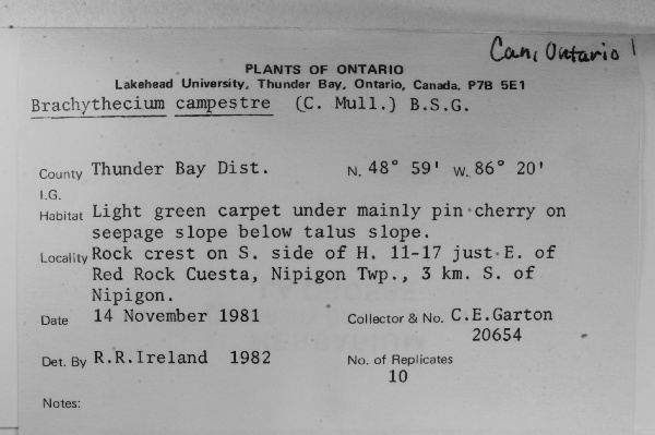
"dwc:county": "Thunder Bay",
"dwc:recordedBy": "G.E. Garton",
"dwc:georeferenceSources": "GeoLocate (CoGe)",
"dwc:order": "Hypnales",
"dwc:habitat": "Light green carpet under mainly pin cherry on seepage slope below talus slope.",
"dwc:scientificNameAuthorship": "(Müll. Hal.) Schimp.",
"dwc:occurrenceID": "90209ac8-2151-4aac-8538-e8edb363f450",
"dwc:dateIdentified": "1982",
"id": "2319836",
"dwc:taxonID": "158098",
"dwc:stateProvince": "Ontario",
"dwc:eventDate": "1981-11-14",
"symbiota:recordEnteredBy": "mschlansky",
"dwc:collectionID": "604e38c8-372e-4e95-a520-17ea991a7d0e",
"dwc:institutionCode": "WIS",
"dwc:country": "Canada",
"dwc:georeferenceRemarks": "Highway 11-17 E of Red Rock; Uncertainty is distance to 3 kilometers South of Nipigon",
"dwc:higherClassification": "Plantae|Bryobiotina|Bryophyta|Bryopsida|Bryidae|Hypnanae|Hypnales|Brachytheciaceae|Brachythecium",
"dwc:kingdom": "Plantae",
"dwc:decimalLatitude": "48.9582",
"dwc:associatedOccurrences": "herbariumSpecimenDuplicate: https://bryophyteportal.org/portal/collections/individual/index.php?guid=87f4c9b1-fed5-4100-9662-136408b9fd0d",
"dwc:basisOfRecord": "PreservedSpecimen",
"dwc:genus": "Brachythecium",
"dwc:family": "Brachytheciaceae",
"dc:rights": "http://creativecommons.org/licenses/by-nc/3.0/",
"dwc:identifiedBy": "R.R. Ireland",
"symbiota:recordID": "90209ac8-2151-4aac-8538-e8edb363f450",
"dwc:phylum": "Bryophyta",
"dcterms:references": "https://bryophyteportal.org/portal/collections/individual/index.php?occid=2319836",
"dwc:locality": "Rock crest on S. side of Hwy 11-17 just E. of Red Rock Cuesta, Nipigon Twp., 3.0 Km S. of Nipigon.",
"dwc:geodeticDatum": "WGS84",
"dwc:taxonRank": "Species",
"dwc:class": "Bryopsida",
"dwc:catalogNumber": "WIS-B-0000714",
"dwc:Identification": [
{
"dwc:identifiedBy": "R.R. Ireland",
"dcterms:modified": "2023-04-25 00:57:10",
"dwc:specificEpithet": "campestre",
"idigbio:recordID": "urn:uuid:03884ea3-65f5-4986-9694-84e6a643bdf5",
"coreid": "2319836",
"dwc:scientificNameAuthorship": "(Müll. Hal.) Schimp.",
"dwc:dateIdentified": "1982",
"symbiota:tidInterpreted": "158098",
"dwc:genus": "Brachythecium",
"dwc:scientificName": "Brachythecium campestre"
}
],
"dwc:decimalLongitude": "-88.341098",
"dwc:coordinateUncertaintyInMeters": "4049",
"dwc:georeferencedBy": "afieldwidell",
"dwc:recordNumber": "20654",
"dcterms:modified": "2023-04-25 01:20:34",
"dwc:scientificName": "Brachythecium campestre"
},
"indexTerms": {
"geopoint": {
"lat": 48.9582,
"lon": -88.341098
},
"family": "brachytheciaceae",
"recordset": "62254613-2696-4834-8c58-5c465f70df56",
"dqs": 0.2753623188405797,
"stateprovince": "ontario",
"county": "thunder bay",
"phylum": "bryophyta",
"catalognumber": "wis-b-0000714",
"startdayofyear": 318,
"taxonrank": "species",
"specificepithet": "campestre",
"continent": "north america",
"uuid": "ffd13f6d-6c0d-49c9-9b04-a80192a85e1e",
"countrycode": "can",
"basisofrecord": "preservedspecimen",
"collector": "g.e. garton",
"institutioncode": "wis",
"mediarecords": [
"95ede76e-9806-4a94-b0fb-3303ccb99f8f"
],
"datemodified": "2023-05-05T11:27:50.407546+00:00",
"datecollected": "1981-11-14T00:00:00+00:00",
"etag": "51d1b6e735f39e2b83f819bee5765c805e1e0782",
"recordnumber": "20654",
"hasImage": true,
"kingdom": "plantae",
"highertaxon": "plantae|bryobiotina|bryophyta|bryopsida|bryidae|hypnanae|hypnales|brachytheciaceae|brachythecium",
"collectionid": "604e38c8-372e-4e95-a520-17ea991a7d0e",
"taxonid": "7519556",
"scientificname": "brachythecium campestre",
"indexData": {
"dwc:specificEpithet": "campestre",
"idigbio:dateModified": "2023-05-05T11:27:50.407546",
"dwc:county": "Thunder Bay",
"dwc:recordedBy": "G.E. Garton",
"idigbio:uuid": "ffd13f6d-6c0d-49c9-9b04-a80192a85e1e",
"dwc:locality": "Rock crest on S. side of Hwy 11-17 just E. of Red Rock Cuesta, Nipigon Twp., 3.0 Km S. of Nipigon.",
"dwc:order": "Hypnales",
"dwc:habitat": "Light green carpet under mainly pin cherry on seepage slope below talus slope.",
"flag_gbif_reference_added": true,
"dwc:scientificNameAuthorship": "scimp. (c. müll.)",
"flag_dwc_taxonid_replaced": true,
"dwc:occurrenceID": "90209ac8-2151-4aac-8538-e8edb363f450",
"dwc:dateIdentified": "1982",
"flag_dwc_taxonrank_replaced": true,
"flag_dwc_taxonomicstatus_added": true,
"flag_gbif_genericname_added": true,
"symbiota:recordEnteredBy": "mschlansky",
"dwc:taxonID": "7519556",
"idigbio:parent": "62254613-2696-4834-8c58-5c465f70df56",
"dwc:stateProvince": "Ontario",
"flag_gbif_taxon_corrected": true,
"dwc:eventDate": "1981-11-14",
"flag_dwc_scientificnameauthorship_replaced": true,
"dwc:collectionID": "604e38c8-372e-4e95-a520-17ea991a7d0e",
"dwc:country": "Canada",
"dwc:multimedia": [
{
"dcterms:license": "creative commons attribution share alike 3.0 migrated",
"dcterms:title": "brachythecium rutabulum",
"dcterms:references": "http://commons.wikimedia.org/wiki/file:2005.07.25_10.48.25-p7250016.jpg",
"coreid": "2679851",
"dcterms:identifier": "http://upload.wikimedia.org/wikipedia/commons/8/81/2005.07.25_10.48.25-p7250016.jpg",
"dcterms:source": "german wikipedia - species pages",
"dcterms:description": "brachythecium rutabulum im alten friedhof in bonn.",
"dcterms:creator": "michael becker",
"dcterms:publisher": "wikimedia commons"
}
],
"idigbio:etag": "51d1b6e735f39e2b83f819bee5765c805e1e0782",
"dwc:decimalLatitude": "48.9582",
"flag_dwc_multimedia_added": true,
"id": "2319836",
"dwc:kingdom": "Plantae",
"dwc:georeferenceRemarks": "Highway 11-17 E of Red Rock; Uncertainty is distance to 3 kilometers South of Nipigon",
"dwc:associatedOccurrences": "herbariumSpecimenDuplicate: https://bryophyteportal.org/portal/collections/individual/index.php?guid=87f4c9b1-fed5-4100-9662-136408b9fd0d",
"dwc:basisOfRecord": "PreservedSpecimen",
"dwc:taxonomicstatus": "doubtful",
"dwc:genus": "Brachythecium",
"dwc:continent": "north america",
"dwc:family": "Brachytheciaceae",
"dc:rights": "http://creativecommons.org/licenses/by-nc/3.0/",
"dwc:identifiedBy": "R.R. Ireland",
"flag_dwc_datasetid_added": true,
"dwc:class": "Bryopsida",
"idigbio:isocountrycode": "can",
"dwc:geodeticDatum": "WGS84",
"idigbio:siblings": {
"mediarecord": [
"95ede76e-9806-4a94-b0fb-3303ccb99f8f"
]
},
"symbiota:recordID": "90209ac8-2151-4aac-8538-e8edb363f450",
"dwc:taxonremarks": "possible variant of brachythecium campestre w. p. schimper in b.s.g., 1853",
"flag_idigbio_isocountrycode_added": true,
"gbif:canonicalname": "brachythecium campestre",
"dwc:phylum": "Bryophyta",
"dcterms:references": "https://bryophyteportal.org/portal/collections/individual/index.php?occid=2319836",
"gbif:genericname": "brachythecium",
"dwc:georeferenceSources": "GeoLocate (CoGe)",
"flag_gbif_vernacularname_added": true,
"dwc:institutionCode": "WIS",
"dwc:taxonRank": "species",
"dwc:parentnameusageid": "2679851",
"dwc:higherClassification": "Plantae|Bryobiotina|Bryophyta|Bryopsida|Bryidae|Hypnanae|Hypnales|Brachytheciaceae|Brachythecium",
"dwc:catalogNumber": "WIS-B-0000714",
"flag_gbif_canonicalname_added": true,
"dwc:Identification": [
{
"dwc:identifiedBy": "R.R. Ireland",
"dwc:genus": "Brachythecium",
"dwc:specificEpithet": "campestre",
"idigbio:recordID": "urn:uuid:03884ea3-65f5-4986-9694-84e6a643bdf5",
"coreid": "2319836",
"dwc:scientificNameAuthorship": "(Müll. Hal.) Schimp.",
"dwc:dateIdentified": "1982",
"symbiota:tidInterpreted": "158098",
"dcterms:modified": "2023-04-25 00:57:10",
"dwc:scientificName": "Brachythecium campestre"
}
],
"dwc:decimalLongitude": "-88.341098",
"dwc:scientificName": "Brachythecium campestre",
"flag_dwc_taxonremarks_added": true,
"dwc:georeferencedBy": "afieldwidell",
"flag_dwc_continent_added": true,
"idigbio:recordIds": [
"urn:uuid:90209ac8-2151-4aac-8538-e8edb363f450",
"62254613-2696-4834-8c58-5c465f70df56\\2319836",
"62254613-2696-4834-8c58-5c465f70df56\\90209ac8-2151-4aac-8538-e8edb363f450"
],
"dwc:recordNumber": "20654",
"dwc:datasetid": "de8934f4-a136-481c-a87a-b0b202b80a31",
"flag_dwc_parentnameusageid_added": true,
"dcterms:modified": "2023-04-25 01:20:34",
"dwc:coordinateUncertaintyInMeters": "4049",
"gbif:reference": [
{
"coreid": "2679851",
"dcterms:source": "taxa watermanagement the netherlands (twn)",
"dcterms:bibliographiccitation": "siebel, h. & during, h. (2006)"
}
],
"gbif:vernacularname": [
{
"coreid": "2679985",
"dcterms:language": "fr",
"dcterms:source": "bryoquel : liste des bryophytes présentes au québec-labrador",
"dwc:vernacularname": "brachythèque des champs"
},
{
"coreid": "2679985",
"dcterms:language": "fr",
"dcterms:source": "bryoquel : liste des bryophytes présentes au québec-labrador",
"dwc:vernacularname": "buissonnette des champs"
},
{
"dwc:countrycode": "de",
"dwc:country": "germany",
"dwc:vernacularname": "feld-kurzbüchsenmoos",
"coreid": "2679985",
"dcterms:source": "taxon list of mosses from germany compiled in the context of the gbol project",
"dcterms:language": "de"
},
{
"coreid": "2679985",
"dcterms:language": "en",
"dcterms:source": "bryoquel : liste des bryophytes présentes au québec-labrador",
"dwc:vernacularname": "field ragged moss"
}
]
},
"hasMedia": true,
"coordinateuncertainty": 4049,
"class": "bryopsida",
"occurrenceid": "90209ac8-2151-4aac-8538-e8edb363f450",
"country": "canada",
"locality": "rock crest on s. side of hwy 11-17 just e. of red rock cuesta, nipigon twp., 3.0 km s. of nipigon.",
"canonicalname": "brachythecium campestre",
"eventdate": "1981-11-14",
"flags": [
"gbif_reference_added",
"dwc_taxonid_replaced",
"dwc_taxonrank_replaced",
"dwc_taxonomicstatus_added",
"gbif_genericname_added",
"gbif_taxon_corrected",
"dwc_scientificnameauthorship_replaced",
"dwc_multimedia_added",
"dwc_datasetid_added",
"idigbio_isocountrycode_added",
"gbif_vernacularname_added",
"gbif_canonicalname_added",
"dwc_taxonremarks_added",
"dwc_continent_added",
"dwc_parentnameusageid_added"
],
"taxonomicstatus": "doubtful",
"recordids": [
"urn:uuid:90209ac8-2151-4aac-8538-e8edb363f450",
"62254613-2696-4834-8c58-5c465f70df56\\2319836",
"62254613-2696-4834-8c58-5c465f70df56\\90209ac8-2151-4aac-8538-e8edb363f450"
],
"genus": "brachythecium",
"order": "hypnales",
"datasetid": "de8934f4-a136-481c-a87a-b0b202b80a31"
},
"attribution": {
"uuid": "62254613-2696-4834-8c58-5c465f70df56",
"name": "University of Wisconsin - Madison",
"description": "The University of Wisconsin-Madison Herbarium, founded in 1849, is a museum collection of dried, labeled plants of state, national and international importance, which is used extensively for taxonomic and ecological research, as well as for teaching and public service. It contains the world's largest collection of Wisconsin plants, about one-third of its 1,000,000 specimens having been collected within the state. Most of the world's floras are well represented, and the holdings from certain areas, such as the Upper Midwest, eastern North America and western Mexico, are widely recognized as resources of global significance.",
"logo": "https://bryophyteportal.org/portal/content/collicon/wis.gif",
"url": "http://www.botany.wisc.edu/herbarium/",
"emllink": "https://bryophyteportal.org/portal/content/dwca/wis_dwc-a.eml",
"archivelink": "https://bryophyteportal.org/portal/content/dwca/wis_dwc-a.zip",
"contacts": [
{
"email": "BryophyteConsortium@gmail.com"
},
{
"email": "BryophyteConsortium@gmail.com"
},
{
"email": "kmcameron@wisc.edu"
},
{
"last_name": "Kenneth M. Cameron",
"email": "kmcameron@wisc.edu"
},
{
"last_name": "Kenneth M. Cameron",
"email": "kmcameron@wisc.edu"
}
],
"data_rights": "CC3 BY-NC",
"publisher": "4e1beef9-d7c0-4ac0-87df-065bc5a55361",
"totalCount": 50655
}
}
 The University of Wisconsin-Madison Herbarium, founded in 1849, is a museum collection of dried, labeled plants of state, national and international importance, which is used extensively for taxonomic and ecological research, as well as for teaching and public service. It contains the world's largest collection of Wisconsin plants, about one-third of its 1,000,000 specimens having been collected within the state. Most of the world's floras are well represented, and the holdings from certain areas, such as the Upper Midwest, eastern North America and western Mexico, are widely recognized as resources of global significance.